

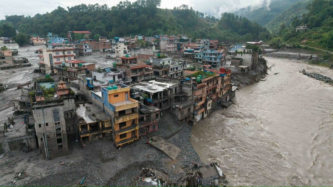
The devastating flash flood that swept through the Nepal–China border region on August 26 began thousands of metres above the settlements it eventually destroyed, after a massive section of glacier and underlying mountain rock collapsed near Langtang Lirung in the central Himalayas.
Satellite images taken before and after the disaster show that the lower section of a glacier near Langtang Lirung broke away at an elevation of around 5,100 to 5,200 metres. Clearer imagery later showed that the disaster involved not only glacier ice but also a major failure of the bedrock underneath it.The collapse sent an enormous mass of ice, boulders and rock crashing hundreds of metres towards the valley floor. What followed was not an ordinary river flood, but a rapidly developing chain of natural hazards.
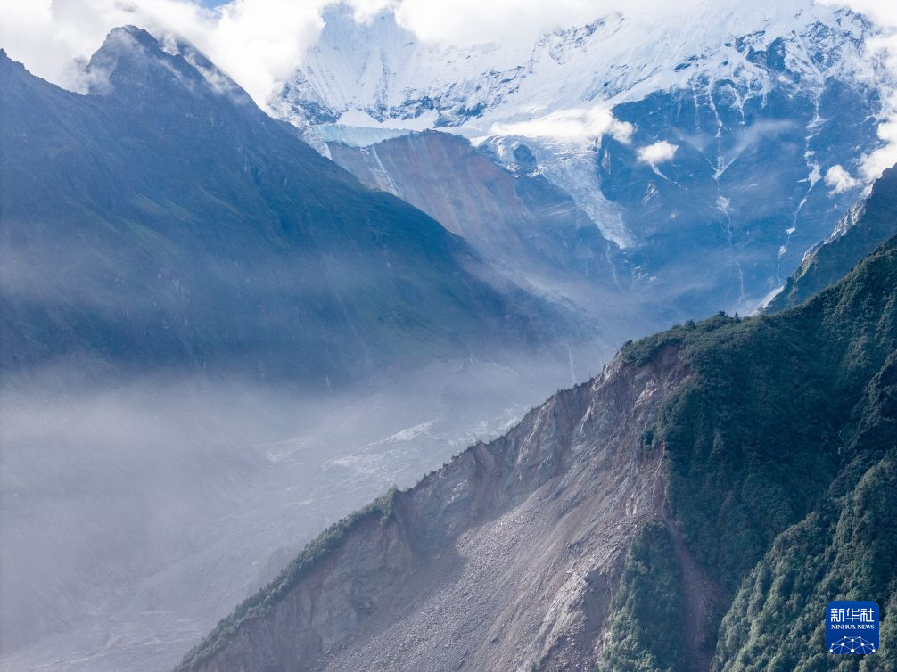
Ice and rock rushed into Lhende Khola
After the initial collapse, the falling mass turned into a powerful ice-and-rock avalanche and swept down the steep valley towards Lhende Khola, a river running through the mountainous Nepal–Tibet border region. As the avalanche travelled downhill, melting ice mixed with river water, mud, rocks and sediment. The flow continued picking up material from the valley, transforming into an enormous high-speed debris flow.
A Chinese government geologist cited by Reuters estimated that the debris flow reached speeds of around 50 metres per second, or roughly 180 kilometres per hour, during part of its journey and extended for more than 20 kilometres. That extraordinary speed gave people downstream almost no time to react.
Gyirong and Rasuwagadhi were directly in its path
The debris-filled flood then rushed towards Gyirong Port in Tibet and the Rasuwagadhi border area of Nepal. The Nepal and Chinese immigration and customs facilities are situated near the meeting point of Lhende Khola and the Bhote Koshi river system, placing the border crossing directly in the path of the incoming surge.
Videos from the area showed a huge brown mass of mud and debris suddenly filling the valley and overwhelming roads, buildings and other infrastructure. Satellite analysis later showed that much of the infrastructure around the border crossing had been caught inside the debris-flow zone.
From Bhote Koshi into the Trishuli
After striking the border region, the flood continued through the Bhote Koshi and Trishuli river systems, carrying huge quantities of water, mud, boulders, trees and other debris deeper into Nepal. The broad path of the disaster can be understood as:
Langtang Lirung glacier area → Lhende Khola → Gyirong/Rasuwagadhi → Bhote Koshi → Trishuli River → downstream Nuwakot and surrounding areas.
The surge travelled past areas including Timure, Syapru Besi, Hakubesi, Betrawati, Trishuli, Devighat and Kolpurtar.
Analysis found that the effects of the flood could be traced for more than 100 kilometres downstream, while the flow descended more than 4,500 metres in elevation from its Himalayan starting point. At Galchhi, downstream river levels reportedly rose by as much as nine metres within just 30 minutes, according to information cited by the International Centre for Integrated Mountain Development.
Why was the flood so destructive?
The enormous destruction was caused by a combination of height, speed, terrain and the amount of debris carried by the flood.The initial collapse happened more than five kilometres above sea level. As the ice and rock plunged through steep Himalayan terrain, gravity allowed the mass to gain tremendous energy. The debris-filled flood is estimated to have reached speeds of around 50 metres per second — roughly 180 km/h — during part of its journey.
The narrow valleys then funnelled the debris rather than allowing it to spread out.At the same time, the moving avalanche collected more water, soil, boulders and sediment, increasing its volume as it travelled downstream.
Satellite images following the disaster showed the Trishuli River dramatically widened and turned brown and black with sediment around places such as Syapru Besi, Betrawati and Kolpurtar. This explains why the event caused damage far beyond the immediate location of the glacier collapse.
But where did such a huge amount of water come from?
One of the biggest questions after the disaster has been how the collapse of part of a glacier could produce such an enormous wall of water.
The answer is that the water did not simply come from the glacier suddenly melting. Preliminary scientific investigations suggest the massive avalanche of ice and rock may have temporarily blocked Lhende Khola, creating a natural dam in the narrow Himalayan valley. River water continued collecting behind the blockage. When the unstable barrier was overtopped or gave way, the accumulated water could have been released suddenly, producing an extremely powerful surge downstream. Scientists are still examining satellite and ground data to determine the exact sequence.
Was it caused by an earthquake?
In the first hours after the disaster, there was speculation that an earthquake may have caused the glacier to collapse.
However, the U.S. Geological Survey later said the seismic signal detected around the time of the event was consistent with energy generated by the huge collapse of glacier ice and rock and the subsequent debris flow. In other words, the available evidence does not currently show that an earthquake occurred first and triggered the disaster. Scientists are still investigating exactly why the mountainside failed.
Not simply a glacial lake outburst
The disaster has also sometimes been described simply as a glacial lake outburst flood, but the latest satellite evidence suggests a more complicated process. The initial disaster appears to have begun with a large bedrock and glacier collapse, followed by an avalanche, debris flow and flash flooding.
The enormous amount of debris deposited during the event subsequently blocked waterways and contributed to the formation of temporary lakes, creating the possibility of further flooding if those natural barriers fail. Authorities have therefore continued monitoring the upper river system even after the first destructive surge passed.
New barrier lake keeps threat of another flood alive
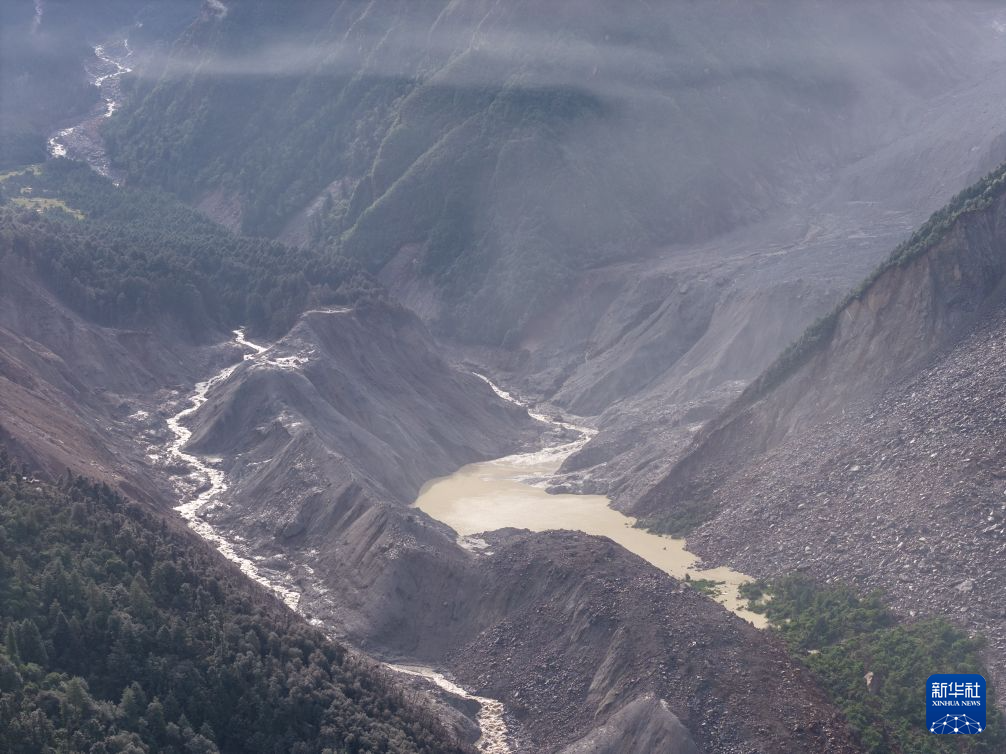
Fears of another flood remain after a large temporary lake formed near Gyirong on the Tibet side of the Nepal–China border, where ice, rock and debris blocked the natural river channel.
The lake sits at around 2,950 metres above sea level, roughly 1,000 metres above Gyirong Port, and is estimated to hold more than 2.5 million cubic metres of water. The natural barrier holding the lake is made of loose rock, mud and avalanche debris. If it suddenly fails, a large volume of water and debris could rush downstream towards Gyirong, Rasuwagadhi and the Bhote Koshi river system.
The lake began overflowing on Friday, briefly forcing rescue operations to stop. Authorities later said the immediate risk had eased, but the area remains under close monitoring because further rain, erosion or another slope collapse could weaken the natural dam.
Death toll continues to rise, thousands still missing
The scale of the human tragedy has continued to grow as rescue teams search communities and river corridors buried beneath mud and debris.
As of Saturday morning, Nepal Police said at least 616 people had been confirmed dead in Nepal, with hundreds still missing across the flood-affected districts. Search operations are continuing and authorities fear the death toll could rise further as more isolated areas become accessible.
Across the wider Nepal–Tibet disaster zone, nearly 2,500 people remain unaccounted for. Earlier official figures showed 1,924 people missing in Nepal and at least 558 missing in Tibet’s Gyirong County.
Foreign nationals are also among those still missing. At least 41 Australians remain unaccounted for, while hundreds of other foreign tourists and pilgrims were travelling through the Nepal–Tibet region when the disaster struck.
With search and rescue operations still underway, authorities have warned that both the confirmed death toll and the number of people located could change rapidly.
Climate change raises wider Himalayan concerns
Scientists have cautioned against declaring climate change the sole cause of this specific collapse before detailed studies are completed.However, warming across the Himalayas is increasingly affecting glaciers and high-altitude permafrost — permanently frozen ground that can help stabilise mountain slopes.
As glaciers retreat and frozen rock and soil thaw, slopes can become increasingly unstable. Experts studying satellite images of the Langtang Lirung collapse say events involving large failures of ice and rock could become more likely as high-mountain environments continue to warm, although the precise trigger of this particular collapse remains under investigation.
The emerging scientific picture therefore shows that the disaster was not one single event, but a devastating chain reaction:
Bedrock and glacier collapse → ice-rock avalanche → Lhende Khola debris flow → Gyirong and Rasuwagadhi → Bhote Koshi → Trishuli River → widespread downstream flooding.
What began as a collapse high near Langtang Lirung became, within a short period, a massive debris-filled flash flood capable of reshaping river channels and devastating communities more than 100 kilometres downstream.